
Posted by phayes on March 24, 2009 at 2:20am
Hi Everyone,
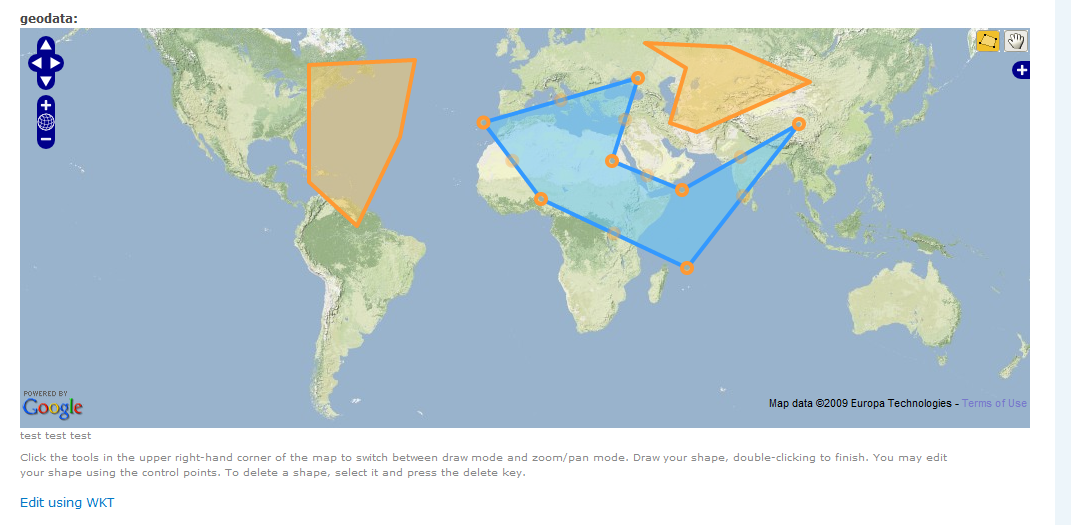
I've developed a module called Geo GUI (http://drupal.org/project/geo_gui). You can download from csv from /contributions/modules/geo_gui.
It uses OpenLayers so that you can draw on a map for inputting polygon, line, and point information in the geo CCK fields. So instead of using WKT to input complex geometries, we can simply draw.
I would love some feedback!
| Attachment | Size |
|---|---|
| geo_gui.png | 309.54 KB |
Comments
Fantastic!
Hi Patrick,
This sounds fantastic!
I'm trying to help Allie with some documentation and feedback on the Geo module, so I'll have a play with this at the same time.
Cheers,
Thomas
http://www.thomasturnbull.com
http://twitter.com/thomasturnbull
Geo module integration?
Patrick,
Does this store the drawn data using the Geo module?
-mike
never mind
Don't bother answering - I answered my own question by looking at the project page. Duh.
Looks fantastic - can't wait to play with it.
-mike
project page update
This looks awesome! I took the liberty of updating the project page to include this image and a bit more of an explanation of why this is useful. Well done!
--
Growing Venture Solutions | Drupal Dashboard | Learn more about Drupal - buy a Drupal Book
knaddison blog | Morris Animal Foundation
Thanks for updating the
Thanks for updating the project page. I just finished coding this yesterday, if anyone wants try to break it / find bugs, I would be really appreciative.
Gmap
We talked about draw tools at Drupalcon DC. Wow, awesome addition to geo. Would Geo GUI be possible with Google Mapping Platform? Or Geo GUI on a iPhone?
Yeah, something similar is
Yeah, something similar is possible with Google Maps--a possible starting point for code would be the "GMap Macro Builder", which lets you draw on a map...
I find OpenLayers to be
I find OpenLayers to be superior to Google Maps for drawing on a map (from a developers perspective - i'm sure you could make it feel the same for a user with enough work). There is no reason however that you could not display the results of this using a google map. This would be simply plugging into the geo module and building out a google maps powered display of the geometries stored by the geo module.
As for an iPhone, I assume you mean as an application? That would be tricky. OpenLayers and GoogleMaps API run on JavaScript, and the iPhone developer agreement explicitly says you cannot write a program that parses code - pretty draconian. Even if you could do it without going against apple decrees, you would need to write a JavaScript interpreter - you might as well write a browser! Might be better just to write an iPhone theme for your drupal page!
FYI - it looks like GeoGUI will be sort lived. It's likely going to be eaten by the geo_cck and OpenLayers module. This is a good thing - it means more people will use it!