
Hi all, Im new to the group, hope you are all well!
I have been switching a site that i have been working on into using Drupal rather than my own fully coded site. So far its all going well and just recently i discovered that Drupal also has support for Google Map API. This is great news as i already have the google api working on my site as i want it so if i can get the Gmap and location modules to acheive what i already have that should almost complete the site and i can go LIVE!
I have managed to setup Gmap and Location, i followed the tutorial on http://www.drupaltherapy.com/gmap. So far i just have a page showing the google map and i have a create marker page under Create Content which populates my map with markers and locations of my choice,
-- See attached Pic-GMap.So.Far.JPG --
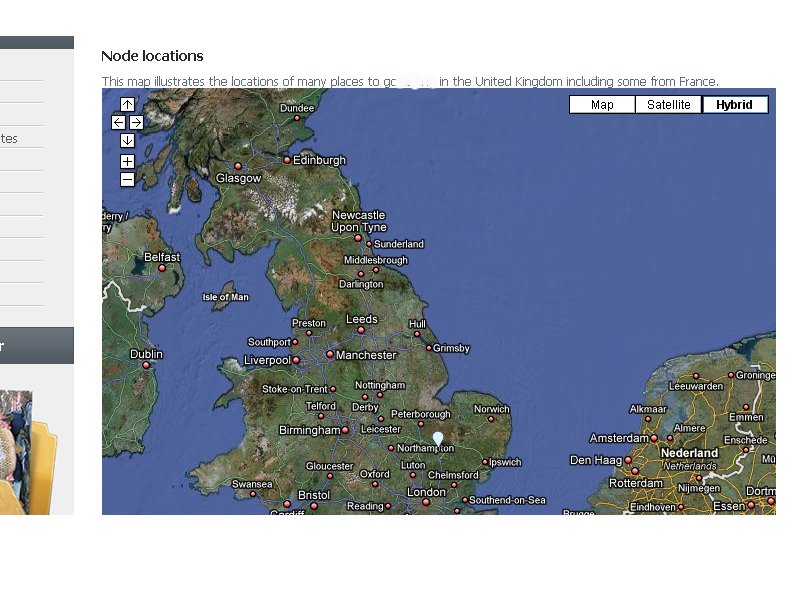
What i want to know is how to best go about getting my markers to function the way they do on my web site where i dont use drupal but i do have a working Google Map with a sidebar that contains a categorised list of all the markers on the site. When i click the links or the markers the map zooms to the location. I am so happy with the functionality i'm looking forward to getting the same working within drupal.
-- See attahced Pic-The.Result.i.Would.Like.JPG --
The below code makes up the 2 files that i use on my web site currently so you can see what code i am using. Hope fully someone can see what im trying to acheive and give me some advice on where to begin.
-- A PHP page that created to show the Google Map --
This is the web page that users view to see the map as it is on attached picThe.Result.i.Would.Like.JPG
<?php
session_start();
<!DOCTYPE html PUBLIC "-//W3C//DTD XHTML 1.0 Strict//EN" "http://www.w3.org/TR/xhtml1/DTD/xhtml1-strict.dtd">
<html xmlns="http://www.w3.org/1999/xhtml" dir="ltr" lang="en-US">
<head profile="http://gmpg.org/xfn/11">
<meta http-equiv="Content-Type" content="text/html; charset=UTF-8" />
<title>My Site</title>
<link rel="stylesheet" href="/css/testnewpage.css" type="text/css" media="screen" />
<script src="maxheight.js" type="text/javascript"></script>
<script src="http://maps.google.com/maps?file=api&v=2&key=MYGOOGLEKEYGOESHERE" type="text/javascript">
</script>
<style type="text/css">
body { height: 600px; font-family: Verdana; }
.normal { background-color:#EFEFEF; }
.focus { background-color:#E0E0E0; }
</style>
</head>
<body onload="load()" onunload="GUnload()">
<div class="column-right maxheight">
<div class="sidebar" overflow:auto; id="sidebar">
</div>
<div class="column-center">
<div class="map" id="map">
</div>
</div>
<script type="text/javascript">
//<![CDATA[
var map, actual;
var gmarkers = [];
var markerdata = [];
var ltblue = new GIcon();
ltblue.image= "images/GoogleMarkerIcons/ltblue-dot.png";
addIcon(ltblue);
var pink = new GIcon();
pink.image= "images/GoogleMarkerIcons/pink-dot.png";
addIcon(pink);
var blue = new GIcon();
blue.image= "images/GoogleMarkerIcons/blue-dot.png";
addIcon(blue);
var brown = new GIcon();
brown.image= "images/GoogleMarkerIcons/brown-dot.png";
addIcon(brown);
var green = new GIcon();
green.image= "images/GoogleMarkerIcons/green-dot.png";
addIcon(green);
var orange = new GIcon();
orange.image= "images/GoogleMarkerIcons/orange-dot.png";
addIcon(orange);
var purple = new GIcon();
purple.image= "images/GoogleMarkerIcons/purple-dot.png";
addIcon(purple);
var red = new GIcon();
red.image= "images/GoogleMarkerIcons/red-dot.png";
addIcon(red);
var white = new GIcon();
white.image= "images/GoogleMarkerIcons/white-dot.png";
addIcon(white);
var yellow = new GIcon();
yellow.image= "images/GoogleMarkerIcons/yellow-dot.png";
addIcon(yellow);
var ltorange = new GIcon();
ltorange.image= "images/GoogleMarkerIcons/ltorange-dot.png";
addIcon(ltorange);
var icons = { "Essex": pink, "Cambridgeshire": brown, "Devon": ltblue, "Lincolnshire": blue, "Suffolk": green, "Hampshire": orange, "Bedfordshire": red, "Cheshire": purple, "Hertfordshire": ltorange, "Norfolk": ltblue, "Surrey": purple, "Yorkshire": yellow, "Cornwall": pink, "Durham": green, "Derbyshire": pink, "Sussex": green };
function addIcon(icon) { // Add icon attributes for all icons
icon.shadow = "http://www.google.com/mapfiles/shadow50.png";
icon.iconSize = new GSize(32, 32);
icon.shadowSize = new GSize(37, 34);
icon.iconAnchor = new GPoint(9, 34);
icon.infoWindowAnchor = new GPoint(19, 2);
icon.infoShadowAnchor = new GPoint(18, 25);
}
// Create the markers and set up the event window
function createMarker(point, name, html, category, id) {
var marker = new GMarker(point, icons[category] );
// Store category, name, id and icon as marker properties
marker.category = category;
marker.name = name;
marker.id = id;
marker.icon = icons[category];
GEvent.addListener(marker, "click", function() {
marker.openInfoWindowHtml(html);
});
// Hovering over the markers
GEvent.addListener(marker, "mouseover", function() {
marker.setImage("images/white-dot.png");
var hovered = document.getElementById(id);
if(hovered) {
hovered.className = "focus";
actual = hovered; // Store this element
}
});
GEvent.addListener(marker, "mouseout", function() {
marker.setImage(icons[category].image);
if(actual) { actual.className= "normal"; }
});
gmarkers.push(marker);
return marker;
}
var hover = { // Hovering over the links
over: function(id) {
// Set another background color for the link
var hovered = document.getElementById(id);
hovered.className = "focus";
// Set another marker icon
for(var i =0; i < gmarkers.length; i++) {
if(gmarkers[i].id == id) {
gmarkers[i].setImage("images/white-dot.png");
}
}
},
out: function(id) {
// Set the default link background
var hovered = document.getElementById(id);
hovered.className = "normal";
// Set the default marker icon
for(var i =0; i < gmarkers.length; i++) {
if(gmarkers[i].id == id) {
gmarkers[i].setImage(gmarkers[i].icon.image);
}
}
}
}
var visible= { // Make a category (un)visible
show: function(category) {
// Show all markers of one category
for(var i= 0; i < gmarkers.length; i++) {
if(gmarkers[i].category == category) {
gmarkers[i].show();
}
}
// Set the checkbox to true
document.getElementById(category).checked = true;
},
hide: function(category) {
// Hide all markers of one category
for(var i= 0; i < gmarkers.length; i++) {
if(gmarkers[i].category == category) {
gmarkers[i].hide();
}
}
// Clear the checkbox of a hidden category
document.getElementById(category).checked = false;
map.closeInfoWindow();
}
}
function boxclick(box, category) {
// Hide or show the category of the clicked checkbox
if(box.checked) { visible.show(category); }
else { visible.hide(category); }
// Rebuild the sidebar
makeSidebar();
}
// Trigger the clicks from the sidebar to open the appropriate infowindow
function Info(i) {
GEvent.trigger(gmarkers[i],"click");
}
// Rebuild the sidebar to match currently displayed markers
function makeSidebar() {
var oldheader;
var html = "";
for(var i= 0; i < gmarkers.length; i++) {
if(!gmarkers[i].isHidden()) {
//var countyLat = gmarkers[i].countyLat;
var header = gmarkers[i].category;
header = header.replace(/^./, header.charAt(0).toUpperCase());
if (oldheader != header) html += '<br \/><li><b><a href="#" onclick="moveMapto('+markerdata[i].countyLat+','+markerdata[i].countyLng+',8);return false;">'+ header+'</a></b></li>';
html += '<a id="'+ gmarkers[i].id+'" href="javascript:Info('+i+')" onclick="moveMapto('+markerdata[i].lat+','+markerdata[i].lng+','+markerdata[i].zoom+');return false;" onmouseover="hover.over(this.id)" onmouseout="hover.out(this.id)">' + gmarkers[i].name + '<\/a><br \/>';
oldheader = header;
}
}
document.getElementById("sidebar").innerHTML = html;
}
// function to deal with having the county headings links to a new location and zoom
function moveMapto(lat,lng,zoom){
map.setCenter(new GLatLng(lat,lng),zoom);
}
//
// This function zooms in or out
// its not necessary to check for out of range zoom numbers, because the API checks
function myzoom(a) {
map.setZoom(map.getZoom() + a);
}
// Create the map
function load() {
if(GBrowserIsCompatible()) {
map = new GMap2(document.getElementById("map"));
map.addMapType(G_PHYSICAL_MAP);
map.addControl(new GLargeMapControl());
map.addControl(new GMapTypeControl());
//map.enableContinuousZoom();
map.enableScrollWheelZoom();
map.setCenter(new GLatLng(52.2195,-3.5),6, G_HYBRID_MAP);
readData();
}
}
function readData() {
var request = GXmlHttp.create();
request.open("GET", "GoogleMarkers.php", true);
request.onreadystatechange = function() {
if(request.readyState == 4) {
// Use the browsers XML parser
// var xml = request.responseXML;
// Use Googles XML parser
var xml = GXml.parse(request.responseText);
var markers = xml.documentElement.getElementsByTagName("marker");
for(var i = 0; i < markers.length; i++) {
// Obtain the attribues of each marker
var lat = parseFloat(markers[i].getAttribute("lat"));
var lng = parseFloat(markers[i].getAttribute("lng"));
var zoom = markers[i].getAttribute("zoom");
var point = new GLatLng(lat,lng,13);
var address = markers[i].getAttribute("address");
var id = markers[i].getAttribute("nr");
var name = markers[i].getAttribute("name");
var html = markers[i].getAttribute("html");
//var html = "<b>"+name+"<\/b><p style='font-size:smaller'>" + address + "<\/p>";
var category = markers[i].getAttribute("category");
var countyLat = parseFloat(markers[i].getAttribute("countyLat"));
var countyLng = parseFloat(markers[i].getAttribute("countyLng"));
// Create the markers
var mdata = new objXMLMarker(lat,lng,zoom,point,address,id,name,html,category,countyLat,countyLng);
markerdata.push(mdata);
map.addOverlay(createMarker(point, name, html, category, id));
}
if(gmarkers) {
// Sort categories and names to display
// both in alphabetic order
gmarkers.sort(compareCats);
markerdata.sort(compareCats);
}
// Show or hide the categories initially
makeSidebar();
}
}; request.send(null);
}
var compareCats = function(a, b) {
var n1 = a.name;
// Treat German umlauts like non-umlauts
n1 = n1.toLowerCase();
n1 = n1.replace(/ä/g,"a");
n1 = n1.replace(/ö/g,"o");
n1 = n1.replace(/ü/g,"u");
n1 = n1.replace(/ß/g,"s");
var n2 = b.name;
n2 = n2.toLowerCase();
n2 = n2.replace(/ä/g,"a");
n2 = n2.replace(/ö/g,"o");
n2 = n2.replace(/ü/g,"u");
n2 = n2.replace(/ß/g,"s");
var c1 = a.category;
var c2 = b.category;
// Sort categories and names
if(a.category == b.category){
if(a.name == b.name){
return 0;
}
return (a.name < b.name) ? -1 : 1;
}
return (a.category < b.category) ? -1 : 1;
}
function objXMLMarker(lat,lng,zoom,point,address,id,name,html,category,countyLat,countyLng){
this.lat = lat;
this.lng = lng;
this.zoom = zoom;
this.point = point;
this.address = address;
this.id = id;
this.name = name;
this.html = html;
this.category = category;
this.countyLat = countyLat;
this.countyLng = countyLng;
}
//]]>
</script>
</body>
</html>
?>-- The code below is the code i use to get the GMarker info from my Database Table.
This is the code that queries my MySQL DB marker table to get the gmarker info, lat, lng etc....
<?
<?php
 require_once('Connections/reg_con.php');
?>
<?php
if (!function_exists("GetSQLValueString")) {
function GetSQLValueString($theValue, $theType, $theDefinedValue = "", $theNotDefinedValue = "")
{
$theValue = get_magic_quotes_gpc() ? stripslashes($theValue) : $theValue;
$theValue = function_exists("mysql_real_escape_string") ? mysql_real_escape_string($theValue) : mysql_escape_string($theValue);
switch ($theType) {
case "text":
$theValue = ($theValue != "") ? "'" . $theValue . "'" : "NULL";
break;
case "long":
case "int":
$theValue = ($theValue != "") ? intval($theValue) : "NULL";
break;
case "double":
$theValue = ($theValue != "") ? "'" . doubleval($theValue) . "'" : "NULL";
break;
case "date":
$theValue = ($theValue != "") ? "'" . $theValue . "'" : "NULL";
break;
case "defined":
$theValue = ($theValue != "") ? $theDefinedValue : $theNotDefinedValue;
break;
}
return $theValue;
}
}
mysql_select_db($database_reg_con, $reg_con);
$query_rts_fisheries = "SELECT counties.county_lat AS countyLat, counties.county_lng AS countyLng, UK_Fisheries.fishery_id, UK_Fisheries.venue, UK_Fisheries.county, UK_Fisheries.lat, UK_Fisheries.lng, UK_Fisheries.img, UK_Fisheries.zoom FROM UK_Fisheries inner join counties on UK_Fisheries.county = counties.county_name ORDER BY UK_Fisheries.county ASC";
$rts_fisheries = mysql_query($query_rts_fisheries, $reg_con) or die(mysql_error());
$row_rts_fisheries = mysql_fetch_assoc($rts_fisheries);
$totalRows_rts_fisheries = mysql_num_rows($rts_fisheries);
?><? header('Content-type: text/xml'); ?>
<?php
 do {
?>
Zoom In</a><a href="javascript:myzoom(-10)">Zoom Out</a><div style="width:310px">
<?php
 echo $row_rts_fisheries['venue'];
?><?php
echo $row_rts_fisheries['img'];
?><?php
echo $row_rts_fisheries['venue'];
?><?php
echo $row_rts_fisheries['county'];
?><?php
echo $row_rts_fisheries['countyLat'];
?><?php
echo $row_rts_fisheries['countyLng'];
?><?php
} while ($row_rts_fisheries = mysql_fetch_assoc($rts_fisheries));
?><?php
mysql_free_result($rts_fisheries);
?>?>
| Attachment | Size |
|---|---|
| GMap.So_.Far_.JPG | 91.26 KB |
| The.Result.i.Would_.Like_.JPG | 124.34 KB |
Comments
How did you get it to work on Drupal?
How did you get this to work in Drupal? I need to do the same thing.